
Best Hiking Trails in the Poconos for Spring
If you are looking for the best hiking trails in the Poconos, spring is the time to find them at their absolute finest. Waterfalls are thundering, wildflowers are carpeting the forest floor, and the tree canopy has not fully leafed out yet, meaning the views from ridgelines and overlooks are wide open and spectacular. As a team that lives and works in the Pocono Mountains year-round, we have hiked every trail on this list multiple times in every season, and we can say with confidence that late March through May is the sweet spot for exploring on foot.
This guide covers our top picks for spring hiking in the Poconos, organized by difficulty. We have included trail lengths, elevation gain, parking details, and honest assessments of what to expect. Whether you are a seasoned backpacker or a family looking for a manageable walk in the woods, there is a trail here for you.
What Makes Spring Hiking in the Poconos Different?
Looking for a base camp for all of this? Pocono Pads Management has a range of fully stocked vacation rentals across the Pocono Mountains — from lakeside cabins to mountain chalets — all professionally managed and guest-ready from the moment you arrive. Browse properties at poconopadsmgmt.com.
Before we get to the trail list, a few things to know about spring conditions in the Poconos:
Trail conditions: Expect mud, especially in April. The snowmelt and spring rains saturate the soil, and some sections of popular trails can be ankle-deep in spots. Waterproof hiking boots are essential, not optional. Gaiters are worth considering for the muddier routes.
Water crossings: Several trails in this guide involve stream crossings that can be tricky in spring. Water levels are higher than summer, and rocks can be slippery. Trekking poles help enormously.
Daylight: By mid-April, you have roughly 13 hours of daylight, giving you plenty of time for longer hikes. Sunrise is around 6:20 AM and sunset around 7:40 PM.
Wildlife: Spring is mating season for many species. You are likely to see white-tailed deer, wild turkeys (especially in April when toms are strutting), black bears emerging from dens, and dozens of migrating bird species. Keep your distance from bears, at least 100 yards, and carry bear-aware habits.
Easy Trails: Great for Families and Casual Hikers
Tumbling Waters Trail
Location: Marshalls Creek, within the Delaware Water Gap National Recreation Area
Length: 3 miles round trip
Elevation gain: Approximately 200 feet
Difficulty: Easy to moderate
Parking: Free lot at the Resica Falls Scout Reservation entrance on Bushkill Falls Road
This is one of our go-to recommendations for families and first-time Poconos hikers. The trail follows a stream through dense hemlock forest, crossing wooden footbridges and passing several small cascades before reaching a 30-foot waterfall at the turnaround point. In spring, the water volume is impressive, and the hemlock canopy keeps the trail cool and shaded. The path is well-maintained but can be muddy in spots, sneakers will work in dry conditions, but we recommend boots in April.
Pro tip: Go early on weekends. This trail has gained popularity in recent years, and the small parking lot fills by 10 AM on Saturday mornings in spring.
Dingmans Falls Trail
Location: Dingmans Ferry, Delaware Water Gap National Recreation Area
Length: 1 mile round trip
Elevation gain: Minimal (boardwalk)
Difficulty: Easy
Parking: Free lot at the Dingmans Falls Visitor Center
This is the shortest hike on our list, but it delivers one of the most impressive payoffs in the entire Poconos. A boardwalk trail leads to Silverthread Falls (a delicate 80-foot ribbon cascade) and then to Dingmans Falls itself, 130 feet of roaring water that is absolutely thunderous in spring. The boardwalk is wheelchair-accessible up to the first viewing platform. The visitor center has restrooms and seasonal ranger programs.
The trail is free and open from dawn to dusk. In spring, the volume of water makes Dingmans Falls feel like a completely different waterfall compared to its late-summer trickle. This is a must-visit in April and May.
Promised Land State Park Loop
Location: Promised Land State Park, near Canadensis
Length: Various options from 1 to 8 miles
Elevation gain: Varies; mostly gentle
Difficulty: Easy
Parking: Free throughout the park; main lots at Pickerel Point and the park office
Promised Land State Park covers over 3,000 acres and has a network of interconnected trails around two lakes, Promised Land Lake and Lower Lake. In spring, the trails are quiet and the birding is exceptional. The Conservation Island Trail (1.5 miles) is a flat, family-friendly loop through mixed forest. For a longer outing, the Bruce Lake Trail (4.5 miles round trip) leads to a remote, pristine glacial lake surrounded by rhododendron and hemlock, gorgeous in any season, but especially peaceful in spring before summer visitors arrive.
Moderate Trails: A Step Up in Challenge and Reward
Cliff Trail at Bushkill Falls
Location: Bushkill Falls, Bushkill
Length: Approximately 2 miles (Red Trail loop)
Elevation gain: Approximately 400 feet
Difficulty: Moderate
Parking: Bushkill Falls parking lot (admission required, approximately $18 for adults in 2026)
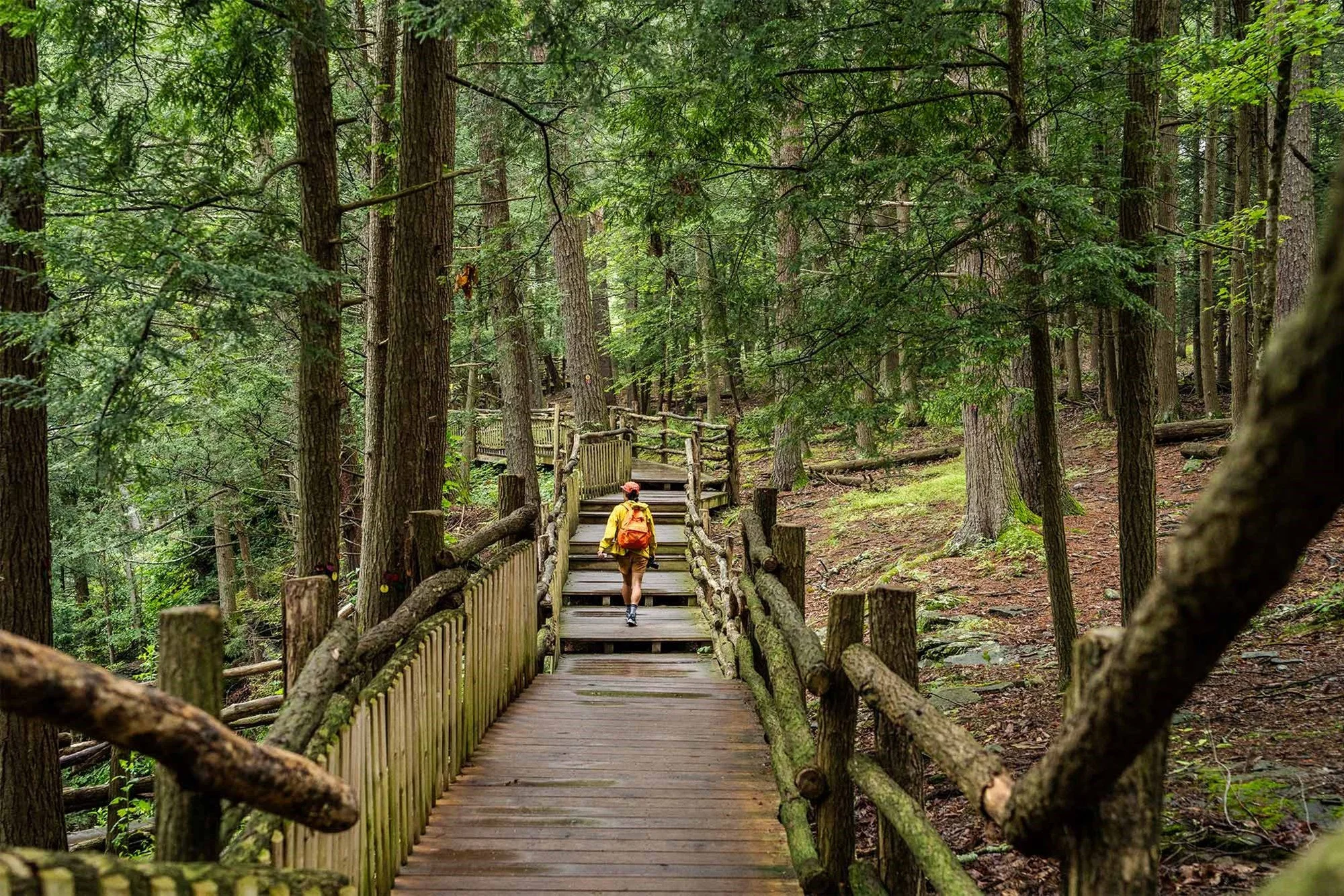
The Cliff Trail is part of the Red Trail loop at Bushkill Falls and is our favorite way to experience the full waterfall network. The trail follows the rim of the gorge, crosses wooden bridges over rushing water, and descends via staircases to viewing platforms at the base of the main falls. In spring, the combination of high water and fresh greenery makes this one of the most photogenic hikes in Pennsylvania.
Be aware: the wooden staircases and boardwalks can be slippery when wet. Take your time, hold the railings, and wear boots with good traction. The park typically opens for the season in early April, we will cover Bushkill Falls in much more detail in a dedicated guide later this month.
Raymondskill Falls Trail
Location: Raymondskill Road, Milford (Delaware Water Gap National Recreation Area)
Length: 1 mile round trip to the lower falls viewpoint
Elevation gain: Approximately 200 feet (mostly stairs)
Difficulty: Easy to moderate
Parking: Small free lot on Raymondskill Road; arrives quickly on weekends
Raymondskill Falls is the tallest waterfall in Pennsylvania at 178 feet, cascading in three tiers through a mossy, fern-draped gorge. The hike is short but involves a steep descent via wooden stairs to the lower viewing area. In spring, the falls are absolutely roaring, you can hear them from the parking lot, and the mist at the base soaks everything within 50 feet.
This is a relatively under-visited waterfall compared to Bushkill and Dingmans, which makes it a favorite among locals. The trail is free and open year-round, though the stairs can be icy in early spring, check conditions before you go.
Lehigh Gorge Trail
Location: White Haven to Jim Thorpe
Length: Up to 26 miles one way (but you can do any portion)
Elevation gain: Negligible (gentle downhill grade from White Haven to Jim Thorpe)
Difficulty: Easy to moderate (distance is the main challenge)
Parking: Free lots at both trailheads; shuttle services available
The Lehigh Gorge Trail follows the abandoned rail bed of the Lehigh Valley Railroad along the Lehigh River through one of the most dramatic gorges in the eastern United States. The trail is crushed stone and mostly flat, making it suitable for hiking and biking. Most people bike this trail using a shuttle service, but hiking a 5- to 8-mile section in spring is a wonderful experience.
The gorge is at its most dramatic in spring when the river runs high and fast, this is also prime whitewater rafting season, and you will see kayakers and rafters on the river below. Wildflowers line the trail, and the exposed cliff faces and rock cuts from the railroad era add a fascinating industrial-history element.
If you hike the southern section into Jim Thorpe, you can reward yourself with lunch or a beer in one of the most charming small towns in Pennsylvania.
Challenging Trails: For Experienced Hikers
Mount Tammany via Red Dot Trail
Location: Delaware Water Gap (New Jersey side, but the most iconic Poconos-area hike)
Length: 3.5 miles (loop combining Red Dot and Blue Dot trails)
Elevation gain: Approximately 1,250 feet
Difficulty: Strenuous
Parking: Free lot at the Dunnfield Creek Natural Area on I-80 (fills early on weekends, arrive before 8 AM in spring)
If you are planning a trip around these experiences, Pocono Pads Management can match you with a rental that puts you close to the action. Our properties are vetted, well-maintained, and stocked with everything you need for a comfortable stay.
Mount Tammany is the crown jewel of Poconos-area hiking. The Red Dot Trail climbs relentlessly from the I-80 parking area to the 1,527-foot summit, gaining over 1,200 feet in about 1.5 miles. The reward is a panoramic view of the Delaware Water Gap, the dramatic notch where the Delaware River cuts through the Kittatinny Ridge, that ranks among the most photographed vistas in the mid-Atlantic.
In spring, the view is especially good because the trees on the ridgeline have not fully leafed out, giving you a wider panorama than you would get in summer. The downside: the Red Dot Trail is rocky, steep, and requires hand-over-foot scrambling in several sections. This is not a casual walk. Wear proper hiking boots, bring water, and take your time on the descent (most injuries on this trail happen on the way down).
The loop route descends via the Blue Dot Trail, which follows Dunnfield Creek back to the parking area. The creek is beautiful in spring, with small waterfalls and deep pools.
Mount Minsi
Location: Delaware Water Gap (Pennsylvania side)
Length: 5 miles round trip
Elevation gain: Approximately 1,000 feet
Difficulty: Moderate to strenuous
Parking: Free lot at the Lake Lenape trailhead on Mountain Road
Mount Minsi is the Pennsylvania counterpart to Mount Tammany, sitting on the opposite side of the Delaware Water Gap. The summit is 1,463 feet, and the trail is well-maintained with a more gradual grade than Tammany's Red Dot. The views from the top look east across the gap to Mount Tammany and down to the Delaware River, a stunning perspective, especially in the golden light of late afternoon.
The trail passes through mixed hardwood forest and a boulder field that provides habitat for the endangered timber rattlesnake. Stay on the trail and watch where you step, especially in warm spring weather when snakes are emerging from their hibernacula.
Pocono Environmental Education Center (PEEC) Trail System
Location: Dingmans Ferry, within the Delaware Water Gap National Recreation Area
Length: Multiple trails ranging from 0.5 to 5 miles
Elevation gain: Varies
Difficulty: Easy to moderate
Parking: PEEC campus parking (free)
PEEC sits on 38 acres with access to thousands of acres of national recreation area land. Their trail system is well-marked and less crowded than the major waterfall trails. The Fossil Trail (1 mile) is excellent for kids, you can spot ancient marine fossils embedded in the rock. The Two Ponds Trail (2.5 miles) loops through diverse habitats including wetlands, meadows, and mixed forest. PEEC also offers guided hikes with naturalists throughout spring, which are a great way to learn about local ecology.
Trail Etiquette and Safety Tips for Spring
Leave No Trace: Pack out everything you bring in. This includes fruit peels and nut shells, they are not native to these ecosystems.
Yield to uphill hikers: Hikers going uphill have the right of way on narrow trails.
Check conditions before you go: The National Park Service website for Delaware Water Gap and individual state park websites post trail condition updates. After heavy rain, some trails may be temporarily closed.
Tell someone your plans: Let a friend or family member know which trail you are hiking and when you expect to return.
Carry the essentials: Water, snacks, a map (do not rely solely on cell service, it is spotty in much of the Poconos), a first-aid kit, and a fully charged phone.
Watch for ticks: Deer ticks carrying Lyme disease are present in the Poconos. Wear long pants, use DEET or permethrin-treated clothing, and do a thorough tick check after every hike.
Where to Stay for a Hiking-Focused Trip
After a long day on the trails, nothing beats coming back to a comfortable home base with a hot tub, a fire pit, and room to spread out. Our properties at Pocono Pads are strategically located near the best trailheads in the region.
Our Cozy 5BR sleeps 12 guests and has a pool, hot tub, fire pit, and game room, everything you need to recover after a strenuous hike. Soak your tired legs in the hot tub while the kids burn off remaining energy in the game room.
Rustic and Modern sleeps 10 and is just 15 minutes from Camelback Mountain, with a hot tub and fire pit perfect for post-hike relaxation. The property combines a cabin-in-the-woods feel with modern amenities, exactly what you want after a muddy day on the trails.
For larger groups, The Green Monster sleeps 16 and is located near Camelback, giving you easy access to both mountain trails and the resort's adventure park. After hiking, the indoor bar and game area keep the energy going well into the evening.
People Also Ask
Q: Are Pocono Mountains vacation rentals family-friendly?
A: Absolutely. Many Pocono Pads Management properties are specifically designed with families in mind — think game rooms, bunk beds, fenced yards, and easy access to kid-friendly attractions like Camelback, Kalahari, and Bushkill Falls. When you browse our listings at poconopadsmgmt.com, you can filter by group size and amenities so you find a home that actually fits your family, not just one that's technically big enough.
Plan your spring hiking trip by browsing all of our properties at poconopadsmgmt.com. We are happy to recommend trails near whichever property catches your eye, and our team can help you build an itinerary that matches your group's fitness level and interests.